I gave a talk on the memorials inside All Saints Church Whiteparish on 14th July 2024. This page has been prepared as quickly as possible to make available all the information presented on the slides. Further detail and links to make navigation easier will be added over the coming days.
Contents of this page
Initially this page contains the contents of the slides presented at the talk, with a few extra comments for clarification. More detail is being added. Links provided in this contents list take you to directly to specific sections without having to scroll down the page to find them.
To find an individual within this page, you can also use the Index to people at the foot of the page.
- Introduction (which memorials are included)
- Groups of memorials of people in Alderstone Manor, Brickworth House and Cowesfield Spilman:
- St Barbes and Bristows of Alderstone Manor
- Eyres of Brickworth House
- Cowesfield Spilman manor (Cowesfield House) - Hitchcock, Tregagle, Dench, Lawrence
- Other memorials, grouped as far as possible
- Vicars – Jones, Budden, Wane
- Teachers - Williams, Billingham
- Other properties
- The Lynches – Lynch
- Young’s Farm – Young
- One other - Emma Nunn
- Funerary Hatchments in the church in 1838
- Modern generations commemorated in many ways (very briefly)
- At the bottom of this page you can find a plan showing the location of each memorial and a full list in date order.
Note on references: The book 'Hundred of Frustfield' by George Matcham, published in 1844 as part of Sir Richard Colt Hoare's 'History of Modern Wiltshire', has been widely used on this page and is referred to as 'Matcham'. Many of the text copies of inscriptions shown have been copied from this book, and inevitably for a book of that complexity, some minor errors may be present in these extracts. Where I've spotted significant errors, I have added comments or inserted corrected text. Please do let me know if you spot other errors and I'll add corrections.
Which memorials are included?
I've attempted to include every memorial in church, although still keep finding the odd extra one I hadn't spotted. Any more will be added here, of course.
- Wall memorials
- Flat memorial stones on the floor, including those hidden under the 1860 floor.
- Windows
- Very briefly: Modern memorials
Only a tiny selection of the population
The monuments inside the church described here represent a tiny proportion of people who died between 1655 and 1928, most of them were prominent members of the local landed gentry.
- There are roughly 40 memorials in the church
- Representing just 273 years from the 824+ years of the church
- 27 of the visible ones are wall or floor memorials
- 7 people are commemorated on 6 windows
- There are at least 8 floor slabs that we can’t see today, under the 1870 floor
- Altogether these memorials commemorate about 54 people
- Out of maybe 10,000 people from 1200 to the present (824 years) 824x800/70=9417
Sara Atkinson has carried out extensive research into the people buried in the graveyard around the church and has a large database recording the graves and people. She gave a talk on these people and the changing styles of gravestone at the same event as the talk described on this page.
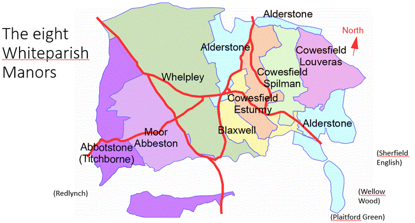
In the beginning this was Alderstone church
- This was Alderstone church, Alderstone being one of the eight Whiteparish manors
- Other manors had or shared chapels of ease
- Cowesfield Esturmy, Cowesfield Spilman and Cowesfield Louveras shared a chapel
- Whelpley had a chapel of its own
- Moor and Titchborne (earlier called Abbotstone) shared a chapel
- Blaxwell probably used Alderstone church
- Lords of Alderstone manor appointed the clergy
- Until 1338 when the manor was given to St Edmund’s College Salisbury
- After 1546 when the College was seized for Henry VIII at the dissolution and sold to William St Barbe
 .
. 
Left: Map emphasising the scattered geography of Alderstone Manor --- Right: Alderstone in the context of a full map of the parish
Blaxwell and the three Cowesfield manors lay between the two main parts of Alderstone
To provide some context to this map, the church is at the lower end of the large area at top left. The large area at bottom right consists essentially of Cowesfield Gate and Bunny Lane and land down towards Plaitford. It is worth being aware that Cowesfield Gate and all its properties were never part of the Cowesfield manors, but in the eastern part of Alderstone. The new 1812 Alderstone manor house at Broxmore House that will be mentioned in more detail below stood near the top of Bunny Lane. [I'll add some labels to the map to make it clearer in the coming days.]
Alderstone Church after 1546
- William St Barbe bought the college for £400 in 1546
- Kept Alderstone and sold the college and its other possessions
- Was then Lord of the Manor and patron of the living
- William (S) – Edward (T) – Edward (U) – Edward d.1671 (V)
- (Edward (T) built the manor house by the church)
 .
. 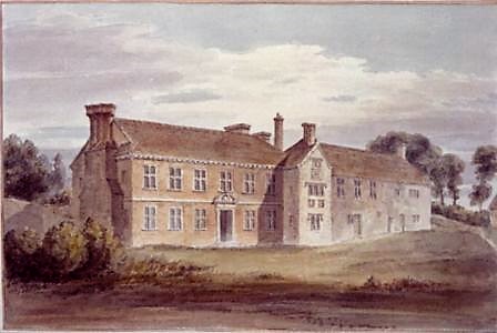
Buckler's paintings of the church and manor house in 1805
The church was changed by Butterfield in 1860 to its present form, the house was demolished in 1812 to build Broxmore House
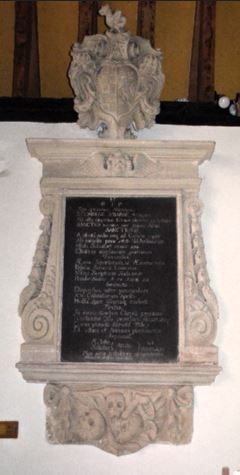
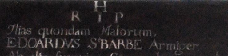
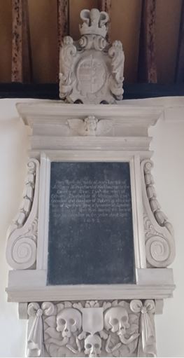
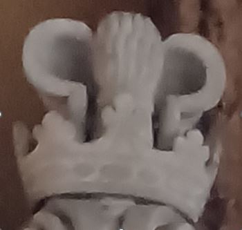
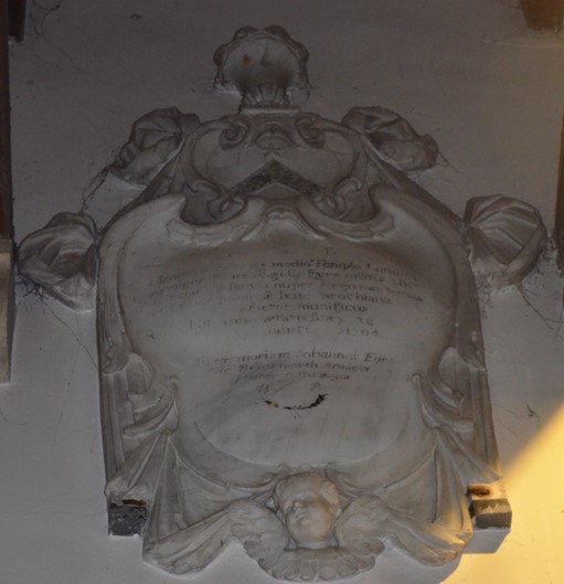
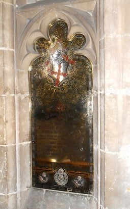
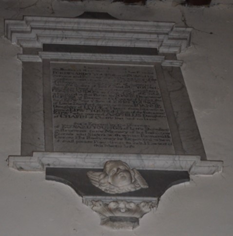
The memorial to Edward St Barbe (V) d.1671
- Lord of Alderstone Manor
- Patron of the living
- His grandfather Edward had built the manor house by the church
- Married Mary Mason
- Immediately to the right of the altar in the sanctuary
The memorial to Mary St Barbe d.1692
- After Edward St Barbe died in 1671 …
- … Mary then married Anthony Hungerford
- In 1655 Anthony had been a secret agent in the Royalist cause in the Civil War
Anthony Hungerford and Mary St Barbe married in Westminster in 1676. He is buried in St Mary's churchyard Blackbourton: "... monument is to Colonel Anthony Hungerford, who died 1703, and was buried in the vault below. It is of white marble, elaborately carved with various instruments of war — the workmanship of which is considered excellent. It bears this inscription:
Near this place lyeth the body of Colonel Anthony Hungerford of Blackbourton of this County [Oxfordshire], second son of Anthony Hungerford of Farleigh Castle in the County of Somerset, Esq. He married Mary Saintbarbe of Whiteparish in the County of Wilts, widdow. He departed this life on the seaventh day of June in the year of our Lord 1703 and in the 69th year of his age.
At the top of the monument is a shield bearing the Hungerford arms: — Sable; two bars argent, in chief three plates and above it the Hungerford garb (wheatsheaf) between two sickles.” Publications, Volumes 34-46 By North Oxfordshire Archaeological Society, p. 44-5". [wikitree.]

. .jpg)
Details of Edward and Mary St Barbe memorials
.
 .
.
 .
.
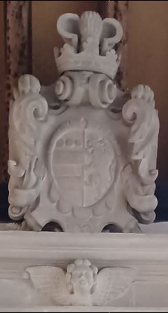
Full memorials left and closer view of heraldic achievement right, for Edward and Mary St Barbe
.jpg)
Explanation of heraldic terms used here to distinguish parts of the heraldic achievement
This image is subject to Creative Commons Attribution-ShareAlike License 4.0, see Wikipedia
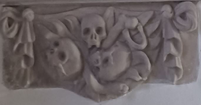
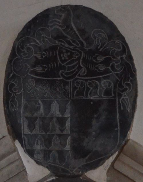
Closer details of Edward and Mary St Barbe memorials
 .
.
 .
.
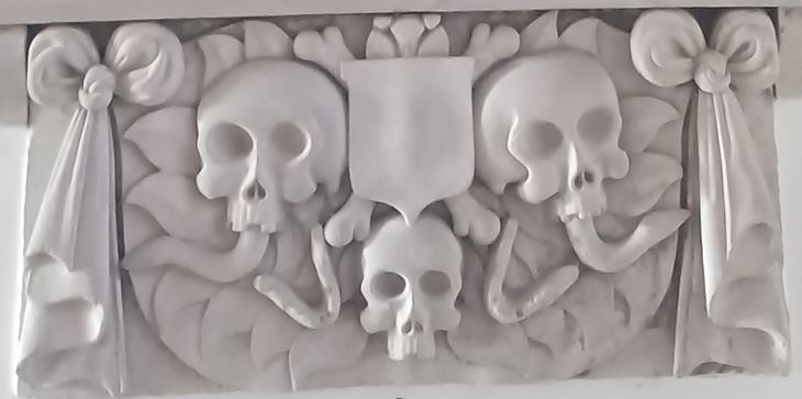
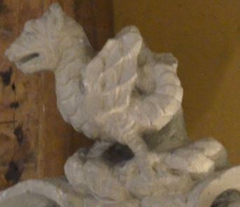
Base of memorial and the crest, top Edward St Barbe, bottom Mary St Barbe
Edward's crest is a Wyvern (mythical dragon), Mary's is a wheatsheaf (known as a garb) with a sickle each side (Hungerford)
The images of skulls, other bones and worms are characteristic of the age
The house and manor stayed in the St Barbe family until 1722
- The house and manor stayed in the St Barbe family from 1546 until 1722
- Bought by George Treby from John St Barbe in 1722
- Three years later bought by Robert Bristow (2) d.1737
- Robert (2) – Robert (3) – Robert (4)
- Robert Bristow (4) demolished the manor house in 1812 and built Broxmore House and Park
. 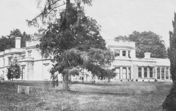
Left the manor house by the church demolished in 1812, right Broxmore House built to replace it
Robert Bristow (4) d.1853
- Married Sophia Twine of Ramsbury
- Son Robert (5) and grandson Robert (6) both died in Sophie’s lifetime
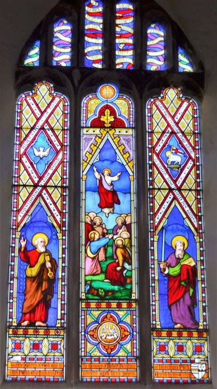
- Robert (5) and two of his sisters also have windows dedicated to them…
 .
. .jpg )
Children of Robert Bristow (4) and Sophia Twine d.1896
 1873.jpg) .
.  1880.jpg) .
.  1883.jpg)
Laura Caroline Knollys d.1873 aged 26 ---- Ada Sophia Kempe d.1880 aged 39 ---- Robert d.1883 aged 39
Sara will have more details of the Twine family locally
Sophia married again
- Robert (4) died in 1853
- Sophia married Major Charles Durie in 1858
- Charles was later promoted to Colonel
- In 1870 Sophia donated the first of two churchyard extensions – intended to coincide with the reopening of the church, but delayed by illness
- As patrons of the living, Charles and Sophia appointed two of Sophia’s relatives as vicars:
- William Twine 1878
- George Augustus, son-in-law of William Twine 1889 or 1887
The June 1870 churchyard extension in yellow
Below it is the 1902 extension, which includes the north half of the St Barbe manor house site, the south half being under the car park
Moving on from Alderstone…
- Only one other manor is represented in memorials in the church – why?
- I’ll cover these memorials later, but here’s some background first
.gif)
See elsewhere on this website for an explanation of how the manorial boundaries shown on this map have been determined [link to be added here]
Manor evolution diagram for the eight Whiteparish manors
The diagram below covering 1066 to 1878 illustrates the way in which manors were gradually divided. At the time of the earliest memorials in church (1655) only Alderstone and Cowesfield Spilman were still being run as manors, and the lords of these manors had elevated status within the community. Owners/lords of the manors shown are those at 1844.
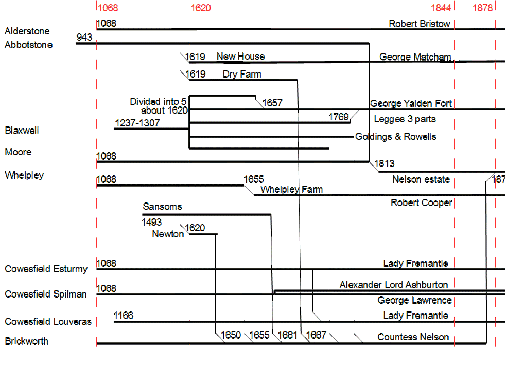
The truncated date on the right hand edge of the diagram should read 1878
A second copy of the diagram has shading emphasising the 1655 line and red lines emphasising manorial ownership where manors were still intact. Although half of Cowesfield Spilman was used as farmland by Melchet Court, Squire Lawrence still held and exercised the manorial title. Lady Fremantle, on the other hand, was an absent landlord, all her land in Cowesfield Esturmy and Cowesfield Louveras being rented out. Robert Bristow used her Cowesfield Louveras as farmland associated with Broxmore House and Park. The Brickworth line at the bottom is spurious as has never been a manor. It is present to show how the Eyre family progressively collected land from all round the parish, generally extending by buying land contiguous with their estate of the time as it came available, but also collecting properties and smallholdings elsewhere and particularly in the village. Although Moor (using the old spelling of Moore on this diagram) also survived intact for longer, it was run as a farm rather than as a manor.
.gif)
Brickworth and the Eyre family
- The prize for the most extensive collection of memorials must surely go to the Eyres of Brickworth
- Land at Brickworth was conveyed on 15th May 1605 to Giles Eyre (1) of Redlynch by Richard Plott of Wantage
- Gyles Eyre (1) built Brickworth House and Park, famously the smallest deer park in England
- The Eyre family became great landowners in the parish
- 237 years later in 1842 the Eyre estate in Whiteparish covered 1355.65 acres
- 21.5% of the parish, and lots of land outside the parish
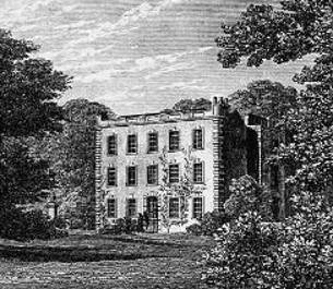 .
. 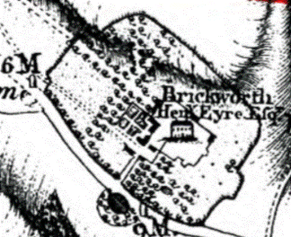
Brickworth House engraving of 1844 and map of Brickworth Park in Henry Eyre's time (1760 to 1799)
The Eyres of Brickworth
Blue shading indicates the eight members of the Brickworth Eyre family. The last Brickworth Eyre, Frances Elizabeth Eyre, married Thomas Bolton in 1821. He became second Earl Nelson in May 1835, when they changed their name to Nelson, were given the Trafalgar estate and moved to Standlynch House, renaming it Trafalgar House. Thomas died a few months later in November 1835, leaving their son Horatio as the third Earl Nelson.
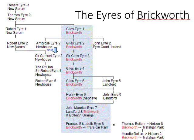
Brickworth House
- 5 generations of Gyles Eyre
- Starting with Gyles Eyre (1) 1572-d.1655 and Jane Snelgrove his wife
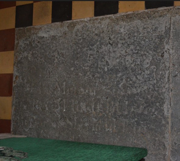
- Wall memorial
- Flat stone marked with GEJ (formatted as shown in the illustration below) in the south aisle under the 1870 floor
 1655 and Jane Snelgrove.jpg) .
. 
Gyles Eyre (1) 1572-d.1655 and his wife Jane
- Some grievances here may have been exaggerated
- £10 plus £100 demanded
- Sheriff of Wilts 1640 not an MP
- Son of a merchant
- Politically out of line locally
- Seriously affected
 1655 and Jane Snelgrove DETAIL.jpg)
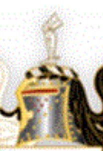
Gyles Eyre (1)
- His helmet and crest hung above the memorial
- Stolen from the church in the 1980s, leaving the crest behind
- The crest was of a dismembered leg (carved in wood)
- “Couped limb of the mailed warrior … ensign borne by the Eyres of Derbyshire and Wiltshire” [Matcham p.55]
- Much fuss in the vestry that Sunday, but where did the leg go?
 .
. 
Left: Eyre crest on helmet; Right: the Eyre crest on the Henry and Harriot Eyre memorial (featured below)

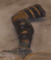
Other examples
By an amazing coincidence, Jane Legat met me at the church door as I arrived to give this talk. In clearing out a cupboard to deal with a bees nest, a package had been found at the back of the cupboard bearing the label: "Wooden crest from an Eyre family memorial, west wall". I was able to unwrap and hold up the leg for all to see!
Here are pictures of the leg, carved in wood, with the binding showing on the left side, thus presumably a left leg;
the toe cap is of leather
[tbd: measure and indicate the size here, or photograph again with a ruler for scale]
Matcham's book 'Hundred of Frustfield' in 1844 has a lovely comment as follows: "In tbe early legends of the family, the crest of the booted leg is said to have been introduced by the chivalrous ancestor, whose loss of limb at Ascalon afforded protection to his gallant chief, Richard Coeur de Lion. This story is probably as veritable as "Near Ascalon's towers John of Horiston slept."
Gyles Eyre (2) 1607-1685
- Gyles Eyre (2) 1607-d.1685 and Ann Norton his wife
- Flat stone in the south aisle (with others)
- Under the floor today so not visible
- No dates on the stone
- Enlarged Brickworth Park
Henry Eyre (2) d.1678 aged 33
- Son of Gyles Eyre (1)
- A younger brother of Gyles Eyre (2) (seven brothers and one sister in the family)
- Outer Bencher of Lincoln’s Inn, MP for Sarum 1638
- Married Margaret Hastings (at one point in Matcham's text he erroneously has put Dorothy Hastings, in the Pedigree chart and elsewhere is correct)
 1678.jpg)
 1678.jpg )
[from Matcham 'Hundred of Frustfield']
John Eyre, probably (2) of Eyre Court
- Flat stone near Henry (2), or may be on the same stone
- Labelled as elder brother of Henry Eyre but no date
- From the context in Matcham, likely to be John Eyre of Eyre Court 1623-1685 so almost certainly not buried here
- John Eyre (2) married Mary Bygoe
- Colonel
- Granted 800 acres in Galway, Ireland
 possibly (2) of Eyre Court.jpg)
The coat of arms description here should suffice to identify this John unambiguously [on my list to be resolved]
[from Matcham 'Hundred of Frustfield']
Sir Gyles Eyre (3) and Dorothy Ryves d.1667
- Sir Gyles Eyre (3) 1635-d.1695
- Lincoln’s Inn Barrister
- Recorder of New Sarum
- Justice of the King’s bench
- Sergeant-at-Law
- MP for Sarum
- Knighted
 1667 and Dorothy Ryves.jpg)
Also flat stone hidden under floor in south aisle: several family members
- Gyles Eyre (2) and Ann Norton his wife
- Sir Gyles Eyre (3) and Dorothy Ryves, first wife
- … and Christabella, Baroness Glasford, second wife
- Divers children
- No date shown
 Ann Norton Sir Gyles Eyre (3) Dorothy Ryves Chritabella Glasford divers children.png)
[from Matcham 'Hundred of Frustfield']
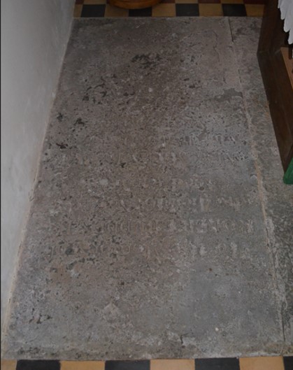
Gyles Eyre (4) and Mabel Thayne
- A flat stone that we can see
- Gyles Eyre (4) 1664-d.1734
- Mabel Thayne d.1728 his wife
- The Thaynes were Lords of the Manor of Cowesfield Spilman (which we’ll be coming back to)
- Almost certainly the Gyles Eyre who built the Pepperbox
- Found when the floor was taken up, where the font was intended to stand
.jpg) .
. .gif) .
.  and Mabel Thayne.jpg)
It had been intended to lift the floorboards next to the font for the talk so that people could see this memorial stone, but the boards were so tightly fitted that we found it impossible to raise them.
Picture of their floor slab after discovery
 and Mabel Thayne as found under floor.jpg)
Gyles Eyre (4) and Mabel Thayne
- "Underneath lye the Bodyes of Gyles Eyre, Esq. Eldest son of Sir Gyles Eyre, Knt And of Mabel his wife. She dyed ye 6 March 1728, aged 74. He ye 28 Nov. 1734, aged 70"
- Arms. – 1 and 4, on a chevron three quatrefoils, Eyre ; 2 and 3 , three oak trees, Snelgrove; impaling three crescents, charged with as many escallops, Thayne
- [Matcham, including his published correction and further corrections to details of my own]
Henry Eyre d.1704 Gyles Eyre (4)’s younger brother
- Middle Temple, one of the four Inns of Court
- Gyles (4) outlived both of his younger brothers
- No other siblings
Henry Eyre d.1704 aged 50

[from Matcham 'Hundred of Frustfield']
John Eyre (4) d.1715 Gyles (4)’s other brother
- d.1715 Aged 50
- Member of 7 parliaments
- Bencher of Lincoln’s Inn
- Flat stone in south aisle (not visible)
 1715.jpg)
[from Matcham 'Hundred of Frustfield']
Gyles Eyre (5) 1692-1750
- Buried in the churchyard at his own specific request, not in the church
- Sara will continue the story here later
- Eyre burials in the church continued

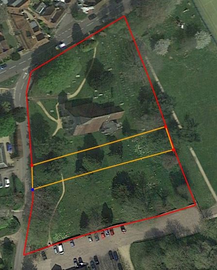
The churchyard divided into three sections
Top: pre-1870 churchyard --- Middle (yellow line) 1870 extension --- Bottom (red line): 1902 extension
Henry Eyre (6) d.1799 and Harriot d.1799
- Henry inherited Brickworth when Gyles (5) died in 1734
- Gyles Eyre (5)'s nephew through his brother John
- Henry had already inherited Landford (half) in 1693 when his father died
- Son of John (5) of Landford, brother of John (6)
- Harriot was also an Eyre, daughter of John Eyre of London
- Erected by John (6)’s children, their nephew and nieces
 1799 and Harriot Eyre 1799.jpg) .
.
Samuel Orr and Jane Eyre
- Samuel Orr d.1812
- Jane d.1826, relict of Samuel Orr and daughter of John Eyre (6) of Landford
- Sister of John-Maurice Eyre (7)
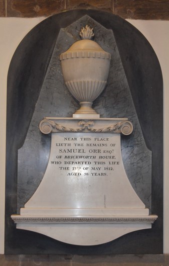 .
.  1812.jpg)
The last two Eyres of Brickworth
- A reminder of the Eyres of Brickworth: Gyles – Gyles – Sir Gyles – Gyles – Gyles – nephew Henry - then his nephew John Maurice followed by daughter Frances Elizabeth
- John-Maurice Eyre (7) d.1815 of Landford inherited Brickworth and Botleigh Grange
- Also bought the other half of Landford
- Frances Elizabeth Eyre (8) his daughter d.1878
- Married Thomas Bolton 1821, second Earl Nelson from May 1835
- Changed name to Nelson, moved to Trafalgar Park (Standlynch)
- Son Horatio Bolton (9) became third Earl Nelson when his father died in November of the same year(1835), changed his name to Nelson
- His mother retained the Brickworth estate until her death in 1878
- On the 1842 Tithe Map, Horatio (9) is Nelson, and his mother Frances Elizabeth (8) is Countess Nelson
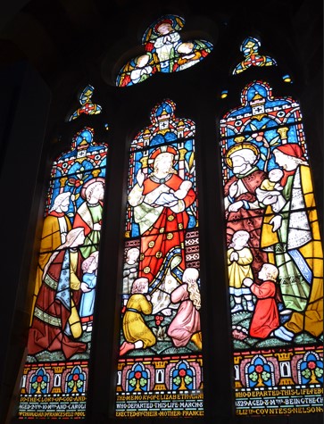
- In 1871, just seven years before her death
- Erected a window to two of her children who had died some 40 years earlier
- Caroline Bolton d.1829 aged 8 months
- Elizabeth Ann Bolton d.1830 aged 2 years and 10 months
- Where the Mothers’ Union altar used to stand
- The new organ with an extra rank of pipes behind blocked this space
- Largely funded by Frances Elizabeth (8) and Horatio (9)
- Hid so many Eyre memorials under the floor
- Cowesfield House, late 16th century farmhouse
- 1767 Henry Dench turned it into a modest country house and park
- 1815 Sir Arthur Paget made further alterations
- Park covered half of Cowesfield Spilman, one of the three Cowesfield Manors
- Built on Common Arable Fields (strips)
- Became the Manor House
- William Hitchcock d.1729 (flat stone in nave)
- William Hitchcock d.1733 and Mary his wife d.1679 (flat stones in nave)
- Francis Tregagle d.1759 and Mary his wife (nave ?wall) above arches in south aisle
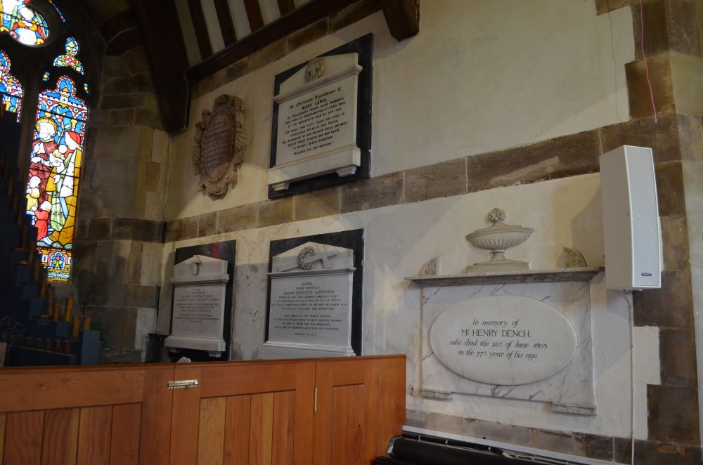
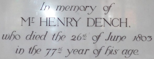
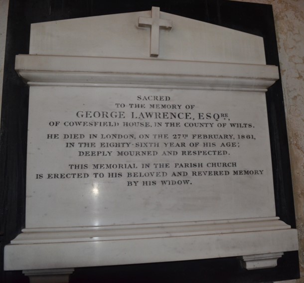
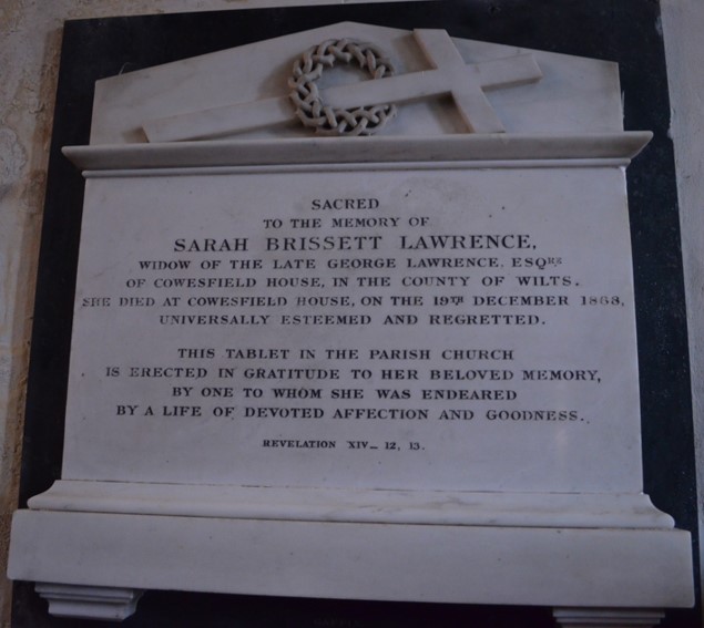
- Henry Dench died 26th June 1803 (south aisle) George Lawrence d.1861 (south aisle east end of outer wall) Sarah Brissett Lawrence 19th December 1868, widow of late George Lawrence
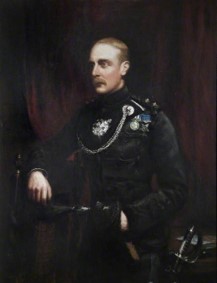
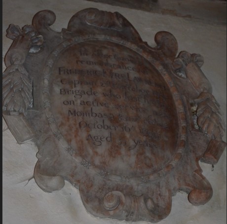
- Frederic Eyre Lawrence 16th October 1895 aged 33 up high in south aisle
- Mary Lewis 9th April 1883 niece of (presumably) George and Sarah Lawrence, lived with them for 50 years at Cowesfield House (high in south aisle)
- In the nave, on flat stones under the floor
- William Hitchcock d.1729 (aged 82)
- William Hitchcock d.1733 (aged 63)
- Mary Hitchcock his wife d.1679
- 1767 Henry Dench turned the farmhouse into a modest country house and park
- Note the shape of George's memorial and its position in the south aisle, and we'll see it later in its earlier position by the chancel arch in a painting of 1869.
- Mary lived at Cowesfield House for more than 50 years
- Captain Frederic Eyre Lawrence of the Rifle Brigade (1861–1895)
- Killed near Mombasa, British East Africa (now Kenya)
- Also has a Winchester Cathedral monument
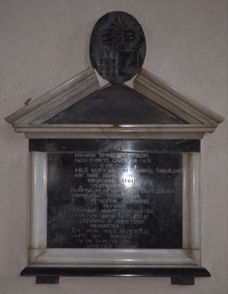
- Morgan Jones d.1688, vicar from 1683 to his death (north aisle on flat stone)
- Rev. Richard Budden d.1769 (will of 1769 in National Archive at Kew) Flat stone in sanctuary, vicar from 1730 to his death in 1769
- Robert Budden d.1822 and wife d.1798 possibly the brother or son of Rev. Richard in the will above (53 years from will) Flat stone in sanctuary
- Rev. John Wane d.1835 in office, classical marble in north aisle, vicar from 1800 to his death, also Rector of Sherfield English
- Also Rector of Sherfield English
- Groups of parishes are not new
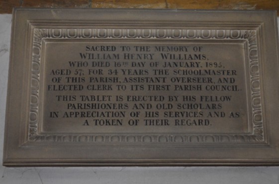
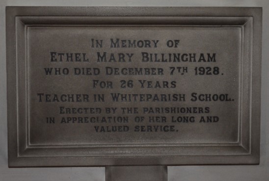
- William Henry Williams d.1895, 34 years schoolmaster, and clerk to the first parish council
- Ethel Mary Billingham d.1928 teacher in Whiteparish School for 26 years
- The Lynches
- Barbara Lynche d.1690, wife of James Lynche
- Flat stone under floor in nave (not visible)
- The house, named after the family that owned it, is still there
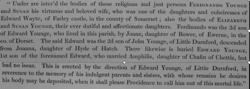
- Edward Young d. 1678
- Ferdinano Younge and his wife Susan Wayte, with Elizabeth and Susan Younge
- The farmhouse is still there
- Named after the Younge family who owned it
- Briars and Dove House stand on the site of the farm buildings
- Pembroke House is next to them across Doves Lane
- Latin and Greek
- A good intellectual challenge
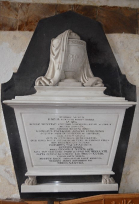
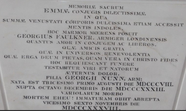
- Emma d.1838, daughter of George Nunn
- Wife of George Faulkner
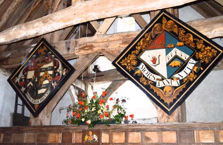
- These paintings show four of the eleven Funerary hatchments and one of the three Lawrence memorials, moved in 1870
- Eleven in the church in 1838
- Sadly probably lost as a result of the Butterfield restoration
- Usually Lord of the Manor or other titled people
- Placed over the door of residence
- Moved into the church after 6 or 12 months
- Black background for parts of the heraldic emblem of the deceased, white for a surviving widow or widower's part of the memorial
- These examples are from Farley Chamberlayne
- These will relate closely to monuments listed above
- I plan to analyse the descriptions below from Matcham to pin them to the individuals concerned
- The families represented as highlighted on the image below are:
- 1. Hitchcock
- 2. Tregagle and Johnson
- 3. Eyre and Eyre, probably Henry (6) d.1799 and Harriot d.1799
- 4. Eyre, Snelgrove and Thayne: possibly Gyles Eyre (4) and Mabel Thayne - further research needed to check this
- 5. Eyre and Snelgrove: Gyles Eyre (1) and his wife Jane Snelgrove
- 6. Eyre
- 7. Eyre and Eyre - see 3 above, either is possible
- 8. Hitchcock
- 9. Hitchcock and Eyre plus three blackamoors' heads
- 10. Hitchcock and Eyre
- 11. Young
- Window etchings
- Furniture
- Churchyard gates
- Hymn boards
- Altar
- Kneelers
- Aumbry
- Stained glass window
- Candlestick
- Many with engraved brass plates
- …and more…
- Kathleen Hayes plate on organ, hymn boards
- Ken and Joan Witchell bookshelves by north door, with mouse carvings
- Ken Wooton 1915-1990 restoration of Commandment Boards
- Hedley and Daphne Hammond churchyard north gate opposite Southdown
- Rt Rev Edmund Robert Morgan (bishop) cross presented by him 1969 Edmund Morgan (bishop) - Wikipedia
- 28th July 1888 – 21 September 1979, Suffragan Bishop of Southampton, Diocesan Bishop of Truro, retired to Whiteparish with his wife Hersey.
- Edmund and Hersey Morgan – plates on the two churchyard gates by the surgery
- Roger Keeley – north aisle altar
- Michael Craik – altar kneeler
- Margaret Danks 1978 (window)
- Cyril Edward George Batchelor (1978) – aumbrey, in sanctuary
- Edward and Lottie Threadgold, by north door
- Rev John Treharne Phillips and his wife Mabel (1978) – Madonna and child - east window in south aisle over Roger Keeley altar
- Mary Wing, Elizabeth Wing, Robert and Mary Gambling - Charity boards
- Marjorie Mayhew - Candlestick
- Baptism boards – lots of people
- War memorial, 20 from WW1 and 7 from WW2
- List of vicars and rectors
- Charity boards in the porch, which are the front panels of the west gallery taken down in 1860
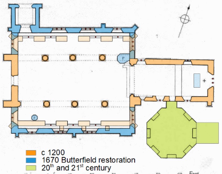
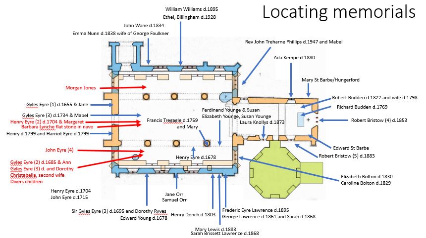
- Plan of church with positions labelled
- List of burials extracted from the parish register by Matcham 1844
- List of memorials in date order
- Eyre family tree from Matcham 1844
- Right click on the image
- Select "open in a new window" or "open in a new tab"
- The new window will enable you to change the scale more easily to make the text readable
Frances Elizabeth Eyre/Bolton/Nelson
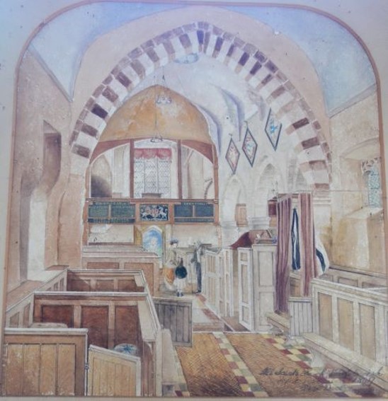
Butterfield church restoration 1870
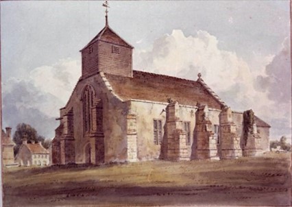 .
. 
Left: the church as painted by Buckler in 1805 --- Right: the Butterfield 1870 alterations in blue
Other Manors, only Cowesfield Spilman
 .
. 
Left: the eight Whiteparish manors --- Right: the three Cowesfield manors, enlarged
Cowesfield Spilman
Cowesfield House, Whiteparish, the 30-room mansion which was formerly the house of the late Mr. W. F. Lawrence, once Postmaster-General, and which is to be demolished.
Salisbury and Winchester Journal of Friday 14th October 1949
Seven Cowesfield Spilman memorials
The three earliest Cowesfield Spilman memorials are not visible today
[from Matcham 'Hundred of Frustfield']
Francis Tregagle of Melchet Park d.1759 and Mary d.1759 his wife
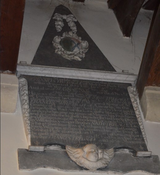
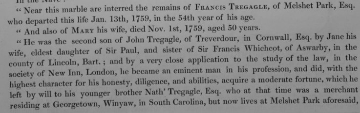
[from Matcham 'Hundred of Frustfield']
Francis Tregagle had the use of Cowesfield House for his lifetime only, after which it returned to his wife Jane's family
Henry Dench d.1803
 .
. 
George Lawrence d.1861, wife Sarah d.1868
 .
. 
Mary Lewis d.1883, niece of George and Sarah

Frederic Eyre Lawrence 1861-1895
 .
. 
Left hand picture: Oxfordshire and Buckinghamshire Light Infantry Museum
Unknown artist
Frederic Eyre Lawrence (Winchester Cathedral)
To the glory of God and
in memory of
Frederick Eyre Lawrence
Captain of the Rifle Brigade
son of General Sir Arthur Lawrence, K.C.B.
Colonel Commandant 2nd Battalion Rifle Brigade
Who was killed
whilst on special service
at Mboyani in East Africa
On 16th October 1895, aged 33 years
His place of death is recorded as Mgobani on the painting in the Rifles Museum, Mboyani on the Winchester Cathedral memorial (above), near Mombasa on the Whiteparish memorial. Could this be the modern Magombani, 14 miles from Mombasa?
Vicars and their relatives
Rev. Richard Budden d.1769 in office, Robert Budden d.1822 and wife d.1798
 .
. 
Rev. John Wane d.1834 in office

Teachers
 .
. 
Other properties near the church - Barbara Lynche d.1690
.jpg)
Young’s Farm
 .
. 
Young’s Farm
.jpg) .
. .jpg)
Two views of Young's Farmhouse taken at different dates
Edward Young d.1678
 .
.  .
. 
Edward Young's coat of arms
Edward Young
My schoolboy and mediaeval Latin isn't up to this one: I'm hoping to be able to provide a professional translation through the granddaughter of a Whiteparish resident, a classics teacher. Of course, if you can provide me a translation of this or any of the other Latin memorials, I would be very pleased.

[from Matcham 'Hundred of Frustfield']
Ferdinando and Susan Younge and their daughters Elizabeth Younge & Susan Younge
[from Matcham 'Hundred of Frustfield']
And one other memorial
 .
. 
1869 before Butterfield Restoration
 .
. 
Funerary hatchments
Hatchments in 1838
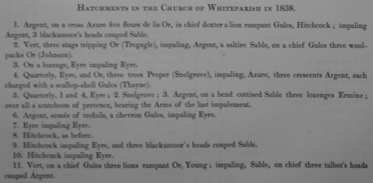
[from Matcham 'Hundred of Frustfield']
Many modern memorials
Modern memorials and records in many forms
I have a separate web page that includes photographs of all these memorials that will be uploaded here as soon as it's complete
Please let me know if there are others that I should have included
Four slides to help locate memorials
Plan of church with positions labelled
Matcham burials selected from the parish register

[from Matcham 'Hundred of Frustfield']
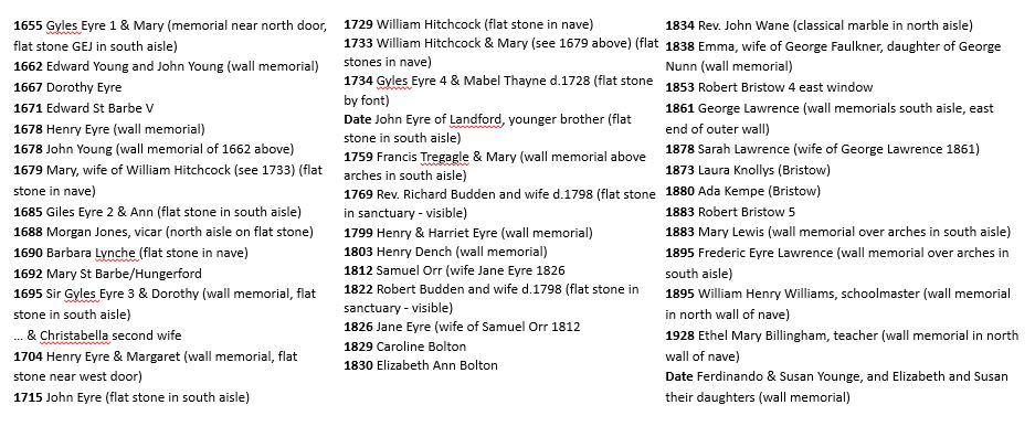
Memorials in date order
Matcham's Pedigree of the family of Eyre of Brickworth, Landford, New Sarum, Eyre Court
To read this image easily:
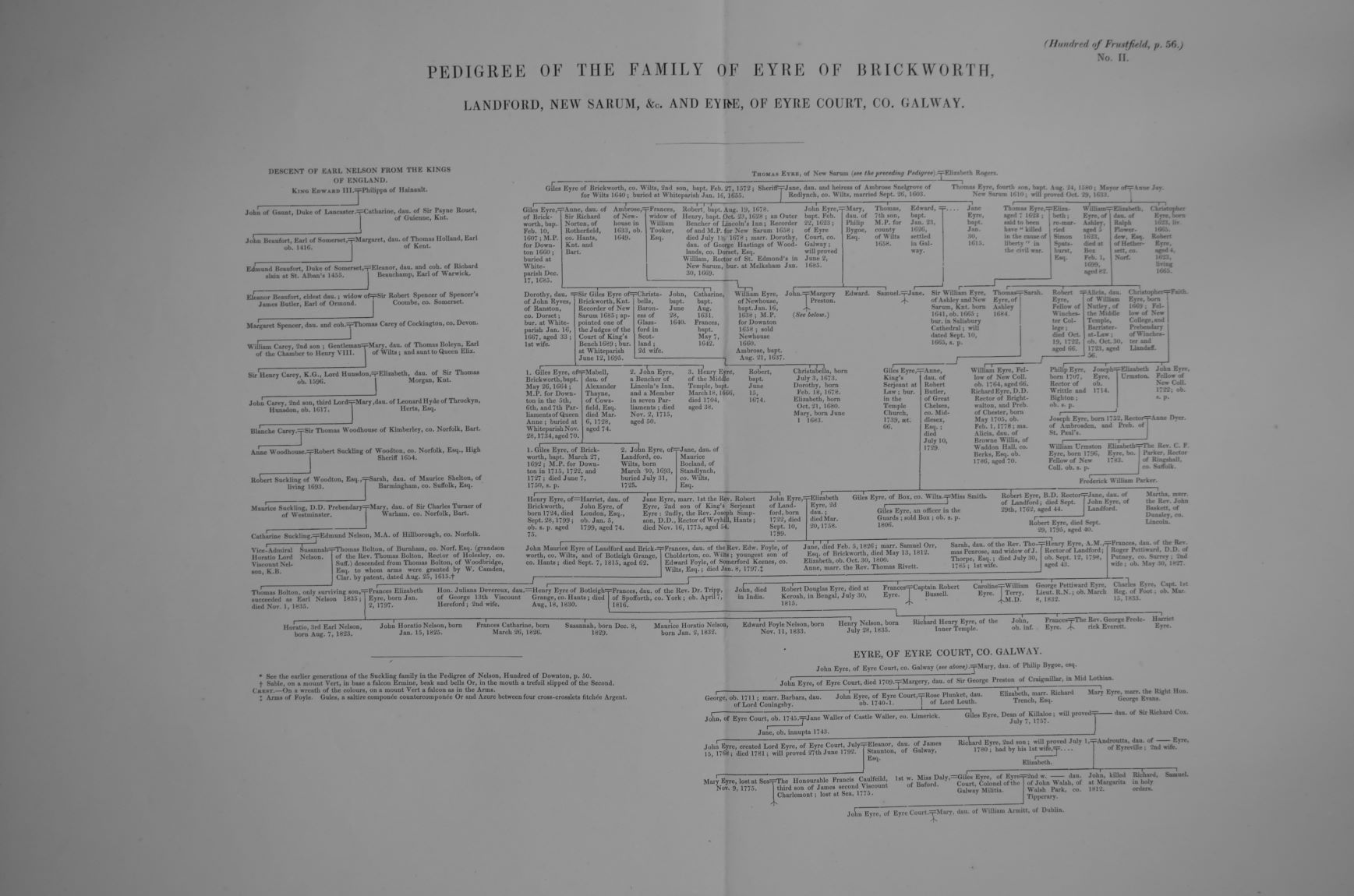
[from Matcham 'Hundred of Frustfield']
Index to people with memorials in church
Listed in alphabetical order of surnames
Ethel Mary Billingham d.1928 teacher (wall memorial in north wall of nave) 503
Caroline Bolton d.1829 525 window behind organ
Elizabeth Ann Bolton d.1830 525 window behind organ
Robert Bristow 4 d.1853 east window (pictures on camera)
Robert Bristow 5 d.1883 window on north side of chancel 519, 520
Rev. Richard Budden d.1769 and wife d.1798 (flat stone under altar) 514, 515, 517, 557
Robert Budden d.1822 and wife d.1798 (flat stone in sanctuary - visible)
Christabella Eyre second wife of Sir Gyles Eyre 3
Henry Dench d.1803 (wall memorial) 530 behind organ on south aisle wall
Dorothy Eyre d.1667 543
Gyles Eyre 1 d.1655 & Mary (wall memorial, flat stone GEJ in south aisle) 545, 550 right of west door
Giles Eyre 2 d.1685 & Ann (flat stone in south aisle) not visible
Sir Gyles Eyre 3 d.1695 & Dorothy (wall memorial, flat stone in south aisle not visible) 543
Gyles Eyre 4 d.1734 & Mabel Thayne d.1728 (flat stone by font) can be seen under trap door by font
Henry Eyre d.1678 (wall memorial) 533
Henry Eyre d.1704 & Margaret (wall memorial, flat stone near west door not visible) 534 + charity bd.
Henry Eyre d.1799 & Harriet Eyre (wall memorial) 544, 547, 550 left of west door
Jane Eyre d.1826 (wife of Samuel Orr 1812, wall memorial) middle of south aisle wall 535, 536
John Eyre d.1715 (flat stone in south aisle) not visible
John Eyre of Landford, younger brother (flat stone in south aisle) not visible
Emma Faulkner d.1838 wife of George Faulkner, daughter of George Nunn (wall memorial) 500
Mary Hitchcock d.1679 wife of William Hitchcock (see 1733) (flat stone in nave) not visible
William Hitchcock d.1729 (flat stone in nave not visible)
William Hitchcock d.1733 & Mary (see 1679 above) (flat stones in nave not visible)
Morgan Jones d.1688 vicar (north aisle on flat stone) not visible
Ada Kempe d.1880 (Bristow) 512 window on north side of chancel
Laura Knollys d.1873 (Bristow) 521, 522, 524 window on south side of chancel by vestry door
Frederic Eyre Lawrence d.1895 (wall memorial over arches in south aisle) 527
George Lawrence d.1861 (wife Sarah 1868) (wall memorial) south aisle, east end of outer wall) 526
Sarah Lawrence d.1868 wife of George Lawrence 1861 (wall memorial) south aisle, east end of outer wall 528
Mary Lewis d.1883 (wall memorial over arches in south aisle) 529
Barbara Lynche d.1690 (flat stone in nave) not visible
Samuel Orr d.1812 (see wife Jane Eyre 1826) (wall memorial) middle of south aisle wall 535, 536
Edward St Barbe V d.1671 (wall memorial) 516 right of altar
Mary St Barbe/Hungerford d.1692 581 left of altar
Francis Tregagle d.1759 & Mary (wall memorial above arches in south aisle) 531
Rev. John Wane d.1834 (classical marble in north aisle) 501
William Henry Williams d.1895 schoolmaster (wall memorial in north wall of nave) 502
George Wing d.1900, Mary, Elizabeth Wing; Robert and Mary Gambling, charity board over north door, 547
Edward Young d.1662 (wall memorial) 541, 542
Ferdinando Younge & Susan Younge, and Elizabeth and Susan their daughters (wall memorial) 532