A Whiteparish local history page from younsmere-frustfield.org.uk
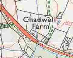
Chadwell Farm is north of the A36 about two thirds of the way from Newton crossroads to its junction with Old Southampton Road (leading to Common Road).

Chadwell Farm (this detailed map is still in copyright, so is not available publicly)
From Matcham 1844
As a working hypothesis, Chadwell Farm corresponds to land owned in 1842 by Downton Free School and occupied by Benjamin Stride, as shown in dark red on these tithe map extracts. The area covered reaches almost to Common Road in Whiteparish, which can be seen at the top left corner of the first (landowners) Tithe map extract below.
This land includes the Chadwell Brick Kiln, with Kiln Yard and Kiln Mead behind it. The field called Chalk Ground alongside the kiln leads one to wonder whether they produced cement too? However, from a geological point of view this field is a long way from the nearest chalk on Dean Hill, lying as it does at the top of the London Clay formation, next to the overlying Lambeth sand. Below the London Clay are the Reading Beds, and the Portsdown chalk lies below that (see the map on the geology page). Another possibility is that the name came from someone's surname - Chalk is a common name in the area: for instance Levy Chalk occupied a garden alongside nearby Barters Farm in 1842.
 landowners.jpg)
Chadwell Farm in 1842, owned by Downton Free School (dark red) Tithe Map landowners
This map has north to the left
 occupiers.jpg)
Chadwell Farm in 1842, occupied by Benjamin Stride (dark red) Tithe Map occupiers
This map has north to the left
Chadwell Farm was owned by the Downton Free School (charity) in 1842. Talking to the owners on [?27th October 2019], I learnt that their father and previous generations had rented and farmed Chadwell Farm up until around 1990, when their father bought the farm. For further details and names see Chadwell Farm Research (this page refers to living individuals, so is not publicly available).